Cities continue to invest in cycling as an environmentally friendly mode of transport, but there are regulations at the federal, state, and local levels that mandate public involvement prior to changing infrastructure. Incorporating stakeholder feedback and then manually rendering revised designs can take multiple weeks, depending on the type and amount of feedback and the complexity of the design.
A team of researchers from Johns Hopkins Whiting School of Engineering, University of Florida, and University of Maryland has developed a new AI-based survey platform that designs bicycle infrastructure using public input. With an AI-image generation tool as the foundation, the new platform uses real-world, street-view images, like those found in Google Maps, to produce realistic, contextually appropriate designs of bicycle facilities to improve the planning and design process.
Susu Xu, principal investigator and assistant professor in the Department of Civil and Systems Engineering at Johns Hopkins says that while places like Baltimore City and Washington, D.C., have design manuals for bicycle infrastructure at street-level, deciphering how the public perceives those designs—particularly whether they feel comfortable or safe—is challenging.
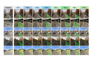
“Traditionally, you hand people a paper survey and ask about bike lanes,” says Xu. “Now, we have a survey framework that can automatically generate and visualize a variety of infrastructure designs based on the streets people are familiar with, like Roland Avenue here in Baltimore, and adjust elements such as buffer placement, car length, and lane width to gauge how they feel about using those bike lanes.”
While image-generative AI models are currently being used to support civil and industrial design, the technology requires large, curated datasets and significant computational resources. The team built their model to overcome these obstacles by combining publicly available bicycle infrastructure images with a type of AI known as reasoning multimodal large language models, or reasoning MLLMs, capable of simulating human cognitive processes like logical thinking and problem-solving, to produce a variety of bicycle facility designs.
The new survey platform is a four-level system built atop an image generation tool. First, multimodal large language models, or MLLMs, are used to capture a location’s spatial relations. Next, user prompts are refined by incorporating illustrative references and contextual descriptions to minimize misinterpretation from survey respondents. Geometric and design-pattern constraints are then separated so that multiple design scenarios can be rendered. Lastly, potential designs are re-ranked based on surveyor input and undergo a compliance check with reasoning MLLMs to ensure lane designs meet the required guidelines.
“Our goal is to understand the true preference of bike lane users,” Xu said. “If a participant says they feel unsafe because the lane is too narrow, the model immediately generates a new design with a wider lane so we can evaluate iterative designs.”
The team’s work extends beyond cycling. By delivering tailored visual outputs linked to survey takers’ environments, the new platform can be applied more broadly to other transportation planning and design projects. It also has the potential to be used in fields like psychology, where researchers seek to approximate group preferences through customized visual surveys.
The team is currently deploying surveys in Washington, D.C., to analyze how different populations perceive the comfort and safety of bike lanes. “We’re trying to improve the safety of bike infrastructure to encourage more cyclists, including e-bike users who can reach speeds of nearly 30 miles per hour,” says Xu. “The outcomes of the survey will have the potential to be incorporated into future design guidelines for the district.”
The study was funded by the National Science Foundation. Additional collaborators include Hopkins research assistant Chenguang Wang, University of Florida’s Xiang Yan and Yilong Dai, and Ziyi Wang from the University of Maryland.